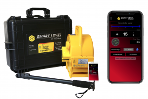
Smart Level combines the accuracy and ease of operation of a precision construction altimeter with your phone or tablet to create maps & photos with the height and distance measurements directly in the image. This works with mobile photos, drone shots, google maps, floor plans, pdf, or even sketched drawings.
- Take a photo or upload an image.
- Set Smart Level where you want to measure.
- Align the crosshairs in the app and click.
Yes it is that easy! Learn More Smart Level LLC | Smart Level Image Mapping