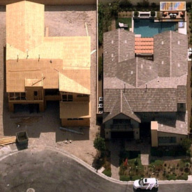
Work smart, build business, reduce your number of site visits and grow your bottom line. Current HD Aerial Imagery helps you swiftly produce better quotes with stunning visuals, precise measurements and greater accuracy. Nearmap captures 430 US cities, often multiple times per year. Leaf-off surveys aid landscape design, and Nearmap’s affordable imagery lets you compete for bigger and better jobs. Far more reliable than satellite, current aerial maps stream instantly from the cloud. View and measure through MapBrowser or integrate further with Autodesk/AutoCAD, and other popular design platforms.