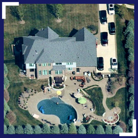
 Landscape contractors have a greener path forward with Current HD Aerial Maps—faster quotes, stronger leads, precise measurements and fewer costly site visits. Nearmap regularly captures 430 US cities, often multiple times per year. Leaf-off surveys aid design, while stunning, affordable imagery lets you compete for bigger and better jobs. Far sharper than satellite, Nearmap Imagery streams instantly to your desktop or mobile device. View and measure through MapBrowser or integrate further with popular design platforms like Autodesk/AutoCAD. It’s time to work smart, speed operations, build business and grow your bottom line.
Nearmap: Aerial Imagery
|
Photo: Greene County Fertilizer Company 28-0-0 GatewayGreene™ is not just another nitrogen product — it’s your turf’s go-to for vibrant green color, controlled growth, and performance that lasts.…Keep Reading
Landscape contractors have a greener path forward with Current HD Aerial Maps—faster quotes, stronger leads, precise measurements and fewer costly site visits. Nearmap regularly captures…Keep Reading