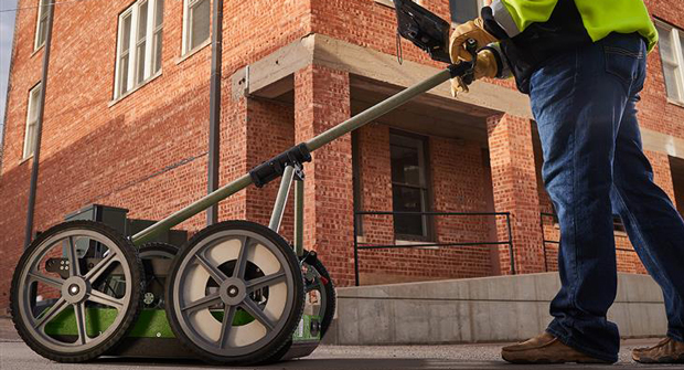
Subsite launched the GeoRanger XR series, a new generation of ground penetrating radar (GPR) systems engineered to transform utility locating for contractors and field professionals. The GeoRanger XR series is made to identify shallow and deep utilities, including those without tracer wires, in a single pass.
GPR technology has changed the way contractors and utility professionals locate underground infrastructure, according to the company. Since its development in the 1970s, GPR has evolved from a niche scientific tool to a mainstream solution for utility detection and subsurface mapping. GPR systems have become more commercially viable over the years, and innovations such as dual-frequency antennas, integrated RTK GPS and wireless connectivity have made modern systems more powerful and user-friendly than ever before.
“With the GeoRanger XR Series, we’re setting a new standard for utility detection,” said Rodolfo Cabello, Subsite utility locating product manager. “These systems empower contractors to efficiently and accurately identify utilities and obstacles, even in the most challenging environments. The combination of advanced technology, intuitive design and robust performance will make a huge impact for contractors in the field, helping them work safer, faster and with greater confidence than ever before.”
The series features the GeoRanger XR and GeoRanger XR2, each designed with distinct capabilities and advantages in the field.
The XR is a versatile, user-friendly system, equipped with dual-frequency antennas (750 MHz and 350 MHz), enabling high-resolution scans without sacrificing depth. The 750 MHz antenna detects objects up to 10 feet deep, while the 350 MHz antenna reaches depths of 20 feet, securing thorough and reliable utility locating, according to the company. Its mobile-friendly design supports both iOS and Android devices for seamless integration and quick deployment.
Building on the XR’s capabilities, the XR2 introduces integrated GPS mapping with RTK correction, reaching up to two-centimeter-level accuracy for precise location data. Pre-loaded with ESSential Underground Post Processing software, the XR2 streamlines data processing and visualization, empowering users to generate detailed reports for informed decision-making. The wireless design eliminates cumbersome cables, enhancing efficiency and ease of use.
According to Subsite, both systems include adjustable cart suspension that allows for smooth movement across rough or uneven terrain, maintaining reliable data quality in a variety of environments.